Plan, Follow, and Share Every Adventure — On One Map
Thred's route builder, powerful outdoor layers, and GPS tracking give adventurers a map built for planning and exploring —
not just getting from A to B.
Build Custom Routes With a Tap — Not a Desktop Browser
Thred's route builder lets you plan where you want to go — before you ever leave the trailhead. Tap the map to place points, snap to existing trails automatically, and shape your line until it looks right.
- Search for a trailhead right from the mapping page to find your starting point
- Tap to place waypoints; each tap extends the route sequentially
- Up to 20 undo steps — double-tap Undo to clear the full route with a confirmation prompt
- Route Tools stack: add weather forecasts to your route, create return routes, or build out-and-back paths
- Save with a name — the activity comes from the routing profile you picked; routes sync to your device and the cloud
The Route Builder is part of the Explorer plan. Recording an activity as you go, and saving up to three routes, are free.


Place waypoints in Place mode, refine in Edit mode, and save your route before you ever leave the trailhead.
Automatic Trail Detection — Your Route Snaps to Real Paths
Thred™ loads trail data in real time and displays it as on the map while you plan. When you place a waypoint near a known trail, path, or track, Thred automatically snaps it to the nearest trail — so your route follows the actual path, not a straight line through the woods.
- Terrain Map with trail overlay shows available paths while you plan
- Waypoints snap to the nearest mapped trail as you place them
- Use any trail, path, road, or off-trail to create your routes. Or switch to Point-to-Point mode and make your own trail around obstacles.
- Trail data is cached locally and usable offline without reloading to speed up mapping and save you on data usage.
Trail snapping is part of the Route Builder, on the Explorer plan.

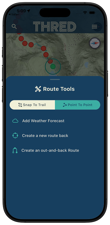
Trails highlight on the map as you plan — tap near any path and your waypoint snaps to the nearest trail automatically.
GPS Route Tracking Across Every Sport
Whether you are hiking a new trail, grinding a mountain bike descent, heading out on a long road ride, or ticking a climbing route — Thred™ maps can record it. Every session is geo-tagged, saved to your profile, and ready to share with your adventure network. Import existing GPS files in GPX, TCX, or FIT format to add routes you already have.
- Hiking, trail running, mountain biking, road cycling, climbing, skiing, and more
- Automatic route recording with elevation and distance
- Any photos taken during an activity are automatically geo-tagged and added to the route timeline
- GPX, TCX, and FIT file import supported
- Sort your saved routes the way you think — the routes list has sort controls
- Track any saved route against your GPS position, with Off Trail Alerts
Recording, saving and Route Tracking are free. Importing GPX, TCX and FIT files from inside the app, geo-tagged photos and changing off-trail alert settings are part of the Explorer plan.

Every session is automatically geo-tagged, saved to your profile, and ready to share — GPX, TCX, and FIT import supported.
Route Analysis: Know What You're Getting Into Before You Leave
Every route in Thred comes with a full analysis sheet — not just distance. Elevation is calculated from the terrain as you build, so you see accurate ascent and descent numbers before you ever start moving.
- Distance, peak elevation, total ascent, and total descent — calculated before you go
- Interactive Elevation profile chart — see what the climbs and descents look like along the route and see when to expect them
- Below the Elevation Profile, weather forecasts saved to your route are viewable. Included: 24-hour hourly forecasts with precipitation chance at each hour, 7-day outlook with 12-hour morning/afternoon splits, and Severe weather alerts are shown automatically in the US — and color-coded by severity
Route analysis and route weather come with the Route Builder, part of the Explorer plan.
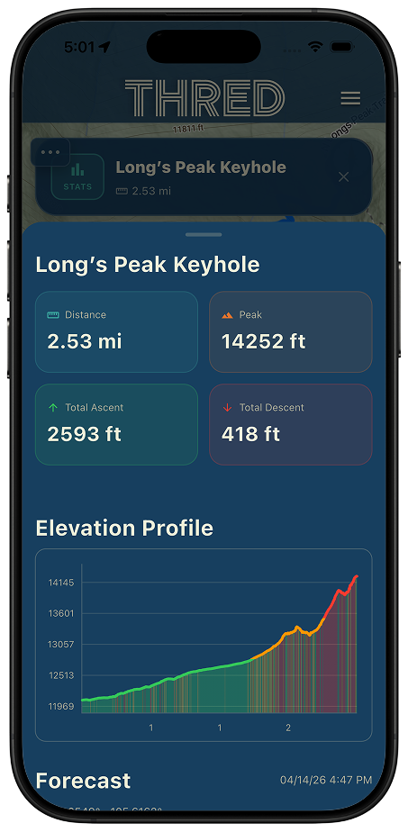
Distance, elevation gain, surface breakdown, and a quality rating — all calculated before you leave home.
Four Basemaps Built for Outdoor Conditions
Switch between four purpose-built basemaps without leaving the app. Choose the view that fits your outing — topo detail for trail planning, satellite for ground truth, or a winter-specific style when you are heading into snow country.
- 2D/3D Terrain — contour lines, elevation shading, full trail detail (default)
- SupaRes 2D/3D — high-resolution outdoor map with up to 1m LIDAR-based resolution (where available)
- Satellite — aerial photography to see actual ground cover before a route
- Winter Sports — styled for ski areas, snowshoe terrain, and snow planning. This basemap is styled to work well with estimated snow-level layers.
2D/3D Terrain is free. SupaRes 2D/3D, Satellite and Winter Sports are part of the Explorer plan.


Overlay Layers Built for Backcountry Planning
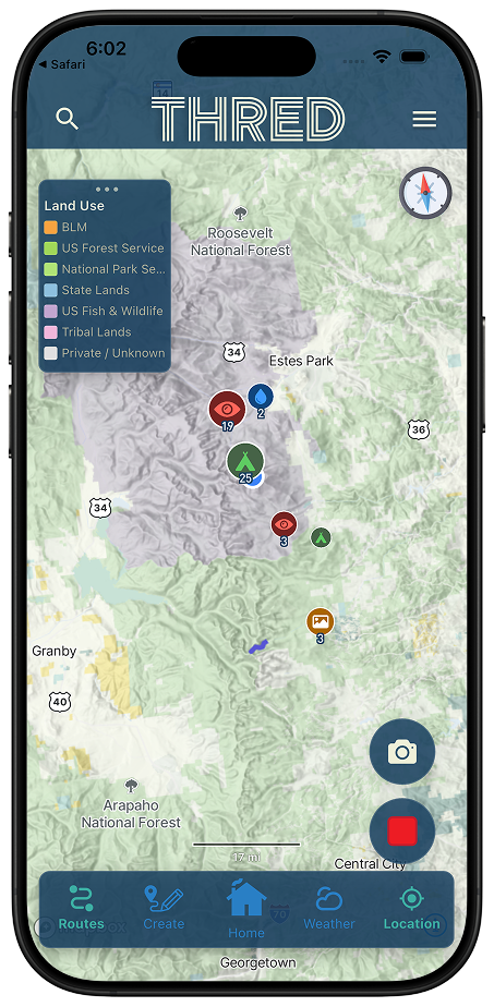
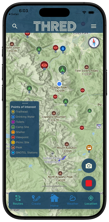
Thred™ adds the layers that matter for backcountry safety and trip planning — avalanche forecasts, measured and estimated snow depth, live radar, slope angle, and land ownership — all stackable and adjustable with opacity controls.
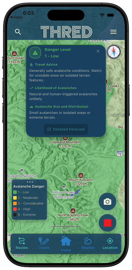
- Avalanche Forecast — danger zones 1–5 from official US forecast centers, updated daily
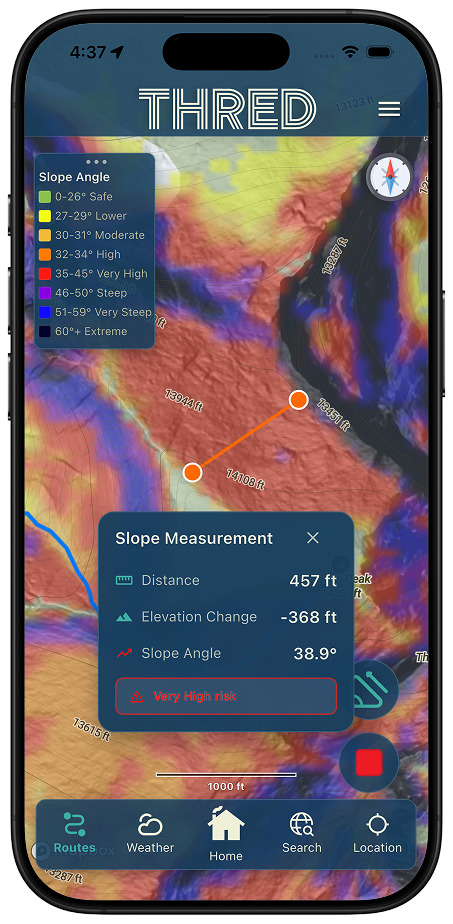
- Slope Angle — color-coded terrain steepness from gentle through 60°+ extreme zones to highlight avalanche-prone areas; use the slope angle tool to measure a slope directly on the map
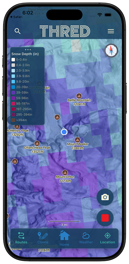
- Estimated Snow Depth — NOHRSC SNODAS model coverage across the entire area
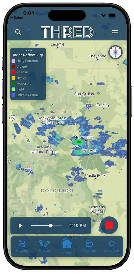
- Live Radar — animated precipitation radar with play/pause and timeline scrubbing
- Land Use — color zones showing who owns or manages the land you're crossing giving you valuable insight on camping and resource avilability
- Points of Interest — trailheads, drinking water, toilets, campsites, shelters, viewpoints and picnic spots, plus every geotagged photo you have taken in the app
The Avalanche Forecast layer is free, and so are wildfire, smoke, weather and contours. Slope Angle, Estimated Snow Depth, SNOTEL, Live Radar, Land Use, the full Points of Interest set and your photo pins are part of the Explorer plan. The slope angle raster currently covers Colorado only.
Live Route Recording With Real-Time Stats on Your iOS Lock Screen
Start recording in Thred™ and a Live Activity launches automatically on iOS. Your route name, elapsed time, and distance update on your Dynamic Island and Lock Screen — so you never need to unlock your phone mid-hike, ride, or run to check progress. Photos you take while recording are geo-tagged and saved with the session.
- Background GPS recording — works with your phone in your pocket or pack
- The map camera can follow you as you move — hands stay on the bars, eyes stay on the trail
- iOS Live Activity on Dynamic Island and Lock Screen with elapsed time and distance
- Full trackpoint stream saved to your route history after every session
- Snap geo-tagged photos mid-recording and find them pinned along the route afterwards
- GPX export from any recorded or imported session — share or load into any GPS device
Recording is free. Geo-tagged photos and GPX export are part of the Explorer plan.
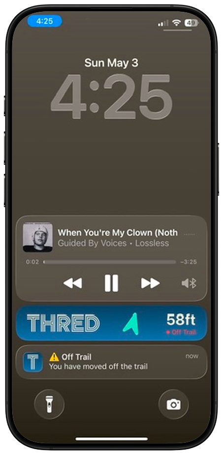
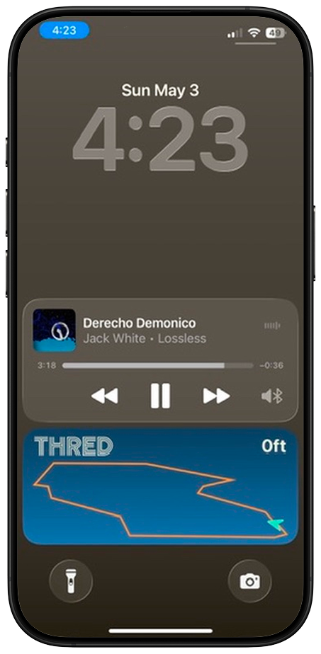
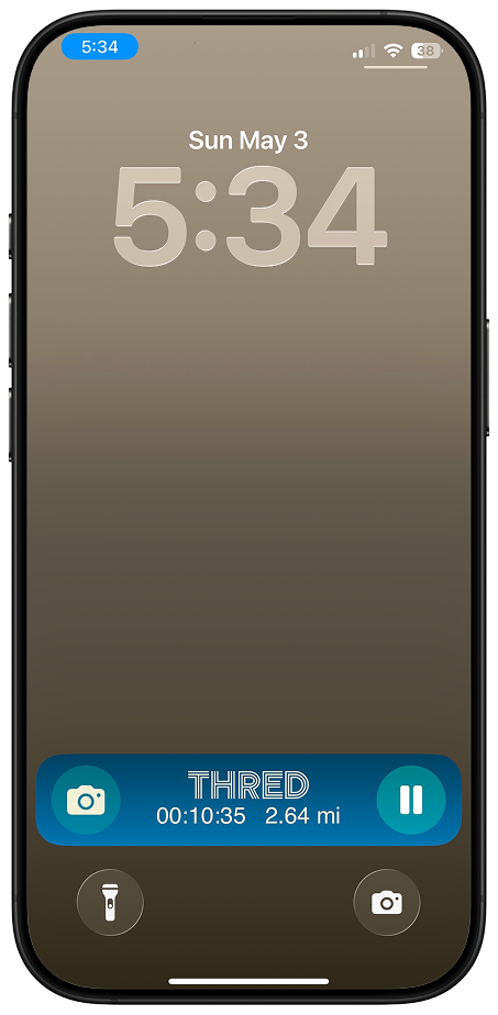
Live Activity keeps your elapsed time and distance visible on your Dynamic Island and Lock Screen — no need to unlock your phone on the trail.
Watch Your Route Come to Life
Adventure Flyby turns any completed route into an interactive 3D fly-through. The camera follows your track over real terrain — every switchback, every climb, rendered the way you experienced it. Play a flyby straight from a feed card, and choose whether to generate one every time you save a recorded route.
- Cinematic 3D fly-through generated from your actual recorded track
- The camera hugs real terrain — not a flat line on a flat map
- Play it right from the feed, or share it with your crew
- Choose whether a flyby is generated every time you save a recorded route

Play a flyby straight from a feed card — the camera follows your real track over real terrain.
Know What's Burning — and Where the Smoke Is Headed
Two map layers put wildfire awareness on your map: Fire Perimeters shows active fire boundaries, and Smoke shows both observed smoke and the forecast, with time controls to scrub ahead.
- Fire Perimeters — active fire boundaries drawn on your basemap
- Smoke — observed smoke plus the forecast, so you can see where it is going
- Time controls scrub the smoke forecast ahead of your trip window
- Check conditions before you commit to a trailhead


Fire perimeters and smoke — observed and forecast — with time controls to scrub ahead.
Read the Terrain Before You're On It
The contour lines layer brings full topographic detail to every basemap — spacing, steepness, and elevation at a glance.
- Contour lines available on every basemap, not just the terrain style
- Line spacing reads steepness at a glance before you commit to a line
- Stacks with the rest of your overlays

Contour spacing tells you how steep it gets — before you are standing in it.
Your Adventures, in Sharper Detail
The activity screen puts your stats up front, with accurate elevation profiles and a perspective map view that renders your route in 3D context.
- Stats layout leads with the numbers you actually look for
- Accurate elevation profiles for every recorded activity
- Perspective map view puts your route in 3D context

Elevation profile and perspective map, on one activity screen.
Your Routes Work With Zero Bars
Saved route details travel with you — stats, descriptions, and maps, available with zero bars. Elevation figures are dead-on even offline: the correction data ships inside the app.
- Saved route stats, descriptions, and maps available without a signal
- Elevation correction data ships inside the app — offline figures stay accurate
- Download map regions ahead of a trip so the basemap comes with you
Offline access to your saved routes and their stats is free. Downloading map regions for offline use is part of the Explorer plan.

Download regions before you go — saved routes and their stats come with you.
Ready to Map Your Next Adventure?
The Thred™ iOS beta is open now; Android is invite-only. Get early access.
Join the Beta Test Crew